4 Minutes
The Discovery of a Global Seismic Mystery
In September 2023, scientists monitoring seismic activity made an astonishing observation: unusual vibrations rippled through Earth, repeating roughly every 90 seconds for nine days. This persistent seismic signal, unlike anything seen before, puzzled researchers across the globe. Just a month later, a nearly identical phenomenon occurred, deepening the mystery and prompting a comprehensive investigation.
Subsequent analysis pointed to an extraordinary explanation—a massive megatsunami, triggered by natural forces in a remote Greenland fjord, reverberating back and forth and generating what physicists call a seiche: a standing wave oscillating within a confined body of water. The event was so energetic, its signature was felt across Earth's seismic network.
Uncovering the Cause: Glacial Melting and Landslide Dynamics
Greenland's Dickson Fjord, an isolated waterway in East Greenland, was the epicenter of this natural drama. According to seismic interpretations, the process began when a melting glacier unleashed two enormous landslides into the fjord. The impact displaced vast volumes of water, setting off powerful tsunamis with waves peaking between 7.4 and 8.8 meters (24.3 to 28.9 feet). With the fjord’s steep, narrow confines, these waves had nowhere to escape, instead slamming against the walls and reflecting repeatedly, forming a sustained seiche that lasted for days.
Remarkably, because of the fjord’s remoteness, no one witnessed the devastation firsthand—not even a military vessel arriving several days into the first incident. The phenomenon only came to light through its seismic echo.
Cutting-Edge Satellite Technology Sheds New Light
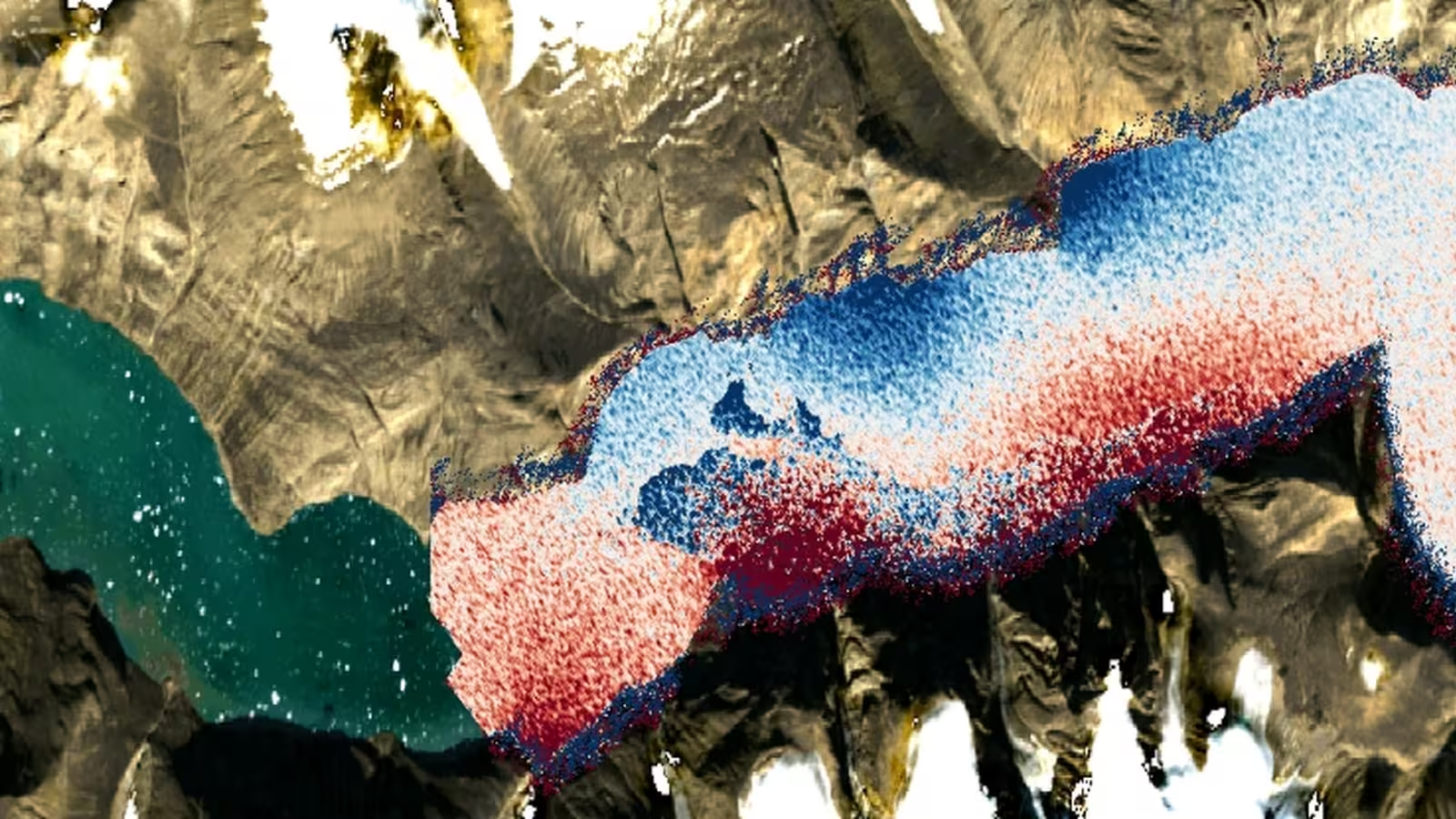
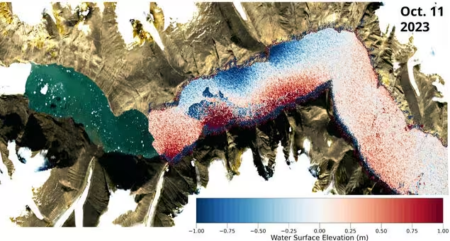
While ground-based sensors registered the earthquake-like signals, deeper understanding required a view from above. Satellite altimetry—which uses radar to measure water surface height—typically lacks the spatial and temporal resolution to catch such fleeting events. However, the recent launch of NASA’s Surface Water and Ocean Topography (SWOT) satellite in 2022 introduced a game-changing tool. SWOT’s advanced Ka-band Radar Interferometer delivers unprecedented precision in mapping water elevations across Earth's surface.
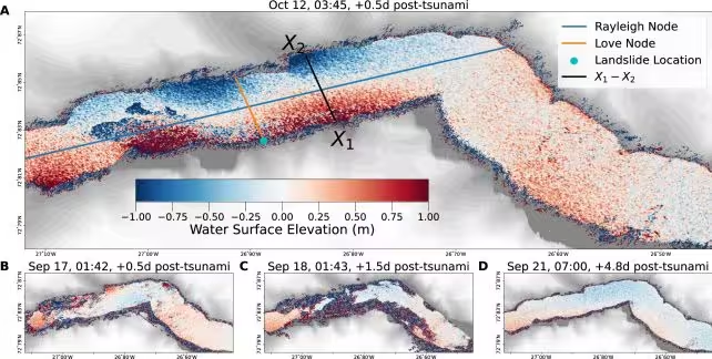
During both the September and October events, SWOT fortuitously captured detailed measurements of Dickson Fjord. Researchers leveraged this high-resolution data to create elevation maps, clearly revealing dramatic fluctuations in the fjord’s surface. The results showed a powerful standing wave, nearly two meters high, resonating back and forth—direct evidence of a seiche and the missing link connecting the seismic signatures to real-world oceanographic processes.
Expert Perspectives and the Power of Satellite Data
“This study exemplifies how new generations of satellite data are resolving mysteries that once seemed beyond our reach,” says Dr. Thomas Adcock, an ocean engineer at the University of Oxford. “Insights like these will revolutionize our understanding of ocean extremes—megatsunamis, storm surges, and anomalous waves. But to unlock their full potential, we need to pair satellite data with innovative machine learning approaches and robust ocean physics expertise.”
The research team didn’t stop at observation: by synchronizing SWOT’s elevation maps with seismic records, they were able to reconstruct wave characteristics and the evolution of both megatsunami events, even in time periods when the satellite was not overhead. This allowed them to confidently eliminate alternative hypotheses for the unusual seismic signals, firmly establishing the seiches as the root cause.
Implications for Climate Science and Future Monitoring
The study’s success signals a new era in geoscience, particularly as rapid climate change accelerates unpredictable extremes in Earth’s most remote regions. Glacial melting and landslides are on the rise, especially in Arctic and subpolar environments where traditional sensor deployments can be challenging or impractical.
"Climate change is spawning unprecedented extremes, evolving fastest in hard-to-reach places like the Arctic,” notes engineer Thomas Monahan, also of the University of Oxford. “Physical sensors alone can't fully track these changes. By harnessing next-generation satellite Earth observation technologies like SWOT, we can gain critical insights into evolving oceanic processes. This is a transformative advancement—previous satellites struggled to penetrate fjords, but SWOT changes the paradigm.”
Conclusion
The first direct observation of the Greenland fjord megatsunami—a seiche event powerful enough to send vibrations across the planet—marks a breakthrough in both seismology and oceanography. Enabled by NASA’s SWOT satellite, the study demonstrates the power of new Earth observation technology to unravel global mysteries and monitor the growing impact of climate change. As scientists continue to integrate high-precision satellite data with machine learning and traditional geoscience, humanity’s capacity to detect, understand, and respond to Earth’s most extreme natural events grows stronger than ever. These discoveries not only inform future hazard assessment and climate models but also showcase the value of international collaboration and technological innovation in unveiling our planet’s hidden dynamics.
Source: doi

Comments