
Flames raced faster than anyone expected. Ridges that had been carpeted in green weeks earlier turned into lines of blazing orange, and whole communities found themselves watching a wall of fire approach.
Researchers with the State of Wildfires Project say the story began months before the first spark. An exceptionally wet winter coaxed vigorous growth across grasslands, shrublands and the shady understories of forests. That lush spring growth looked harmless—almost hopeful. What came next was not. A run of extreme heat and drought baked that new vegetation until it was tinder: abundant, continuous fuel waiting for a trigger.
Then the wind arrived. For several days gusts whipped the flames along the landscape, carrying embers and creating spot fires far ahead of the main front. Wind speeds climbed to about 65 kilometers per hour (40 miles per hour) at times, according to the investigators, turning manageable blazes into rapidly expanding infernos.

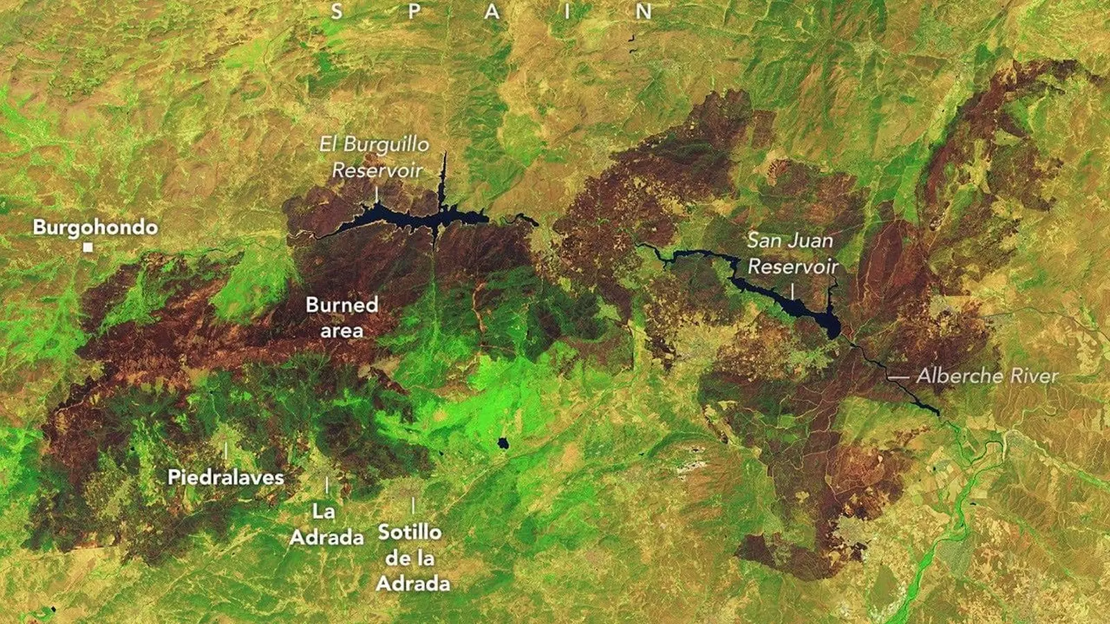
Charred landscapes surround reservoirs in central Spain in an image captured by the OLI (Operational Land Imager) on Landsat 9 on July 29, 2026. The false-color image combines observations at visible, near-infrared, and shortwave-infrared wavelengths (bands 6-5-3), making it easier to distinguish brown burned vegetation from green unburned vegetation.
On July 25 something even more dramatic appeared over southwestern France: a pyrocumulonimbus, the towering thunderhead born out of fire. Firefighters on the ground reported convective columns so intense they fed their own weather. Atmospheric scientists who track these rare "fire clouds" say they have seen them over Spain and Portugal in recent decades, but this was the first confirmed instance tied to a French wildfire.
Thousands of firefighters and military personnel were mobilized across Spain and France, while aircraft poured water and retardant from above. On the ground, crews carved firebreaks with everything from bulldozers to hand tools. By late July, containment efforts had made enough headway that some evacuation orders were lifted, but forecasters warned the risk would stay high as hot, dry conditions persisted.
Watching from orbit, government satellites fed real-time data into a broader international monitoring network. These instruments pinpoint hotspots, map smoke and plume heights, and can flag signatures consistent with pyrocumulonimbus development—information that helps prioritize resources on the ground and track shifting trends in fire behavior.
A wet winter can be as dangerous as a dry one when it primes the landscape for later blazes.
As climate patterns shift and seasons blur, the recent Spain and France fires are a stark reminder that the factors behind catastrophic blazes unfold long before the first spark—and that surveillance, landscape management and rapid response must adapt just as quickly.

Leave a Comment
Comments
No comments yet. Be the first.