
The Pacific is staging a comeback, and scientists are watching like spectators at a tense match. Warm water that normally hugs the western tropical Pacific has surged eastward, and satellite measurements suggest this El Nino could rival—or even eclipse—the record-breaking 1997–98 episode.
Why does that matter? Because El Nino is not a small ripple. When the equatorial Pacific warms, it rearranges weather systems across the globe: droughts that wither crops, wildfires that jump continents, and bouts of heavy rain that flood coastlines. The 1997–98 and 2015–16 events left a legacy of disrupted seasons, and the current pattern is already triggering comparisons.
Remote sensing is doing the heavy lifting. Altimeter satellites measure sea surface height, and when ocean water warms it expands—raising the surface by measurable amounts. That elevated sea level across the central and eastern equatorial Pacific is the ocean’s fingerprint of El Nino. Data from long-running missions, stitched together along nearly identical ground tracks over 35 years, let researchers line up today’s signals against past giants. The result: a striking resemblance to 1997’s footprint, with unusually high water pushing up against the coast of South America.
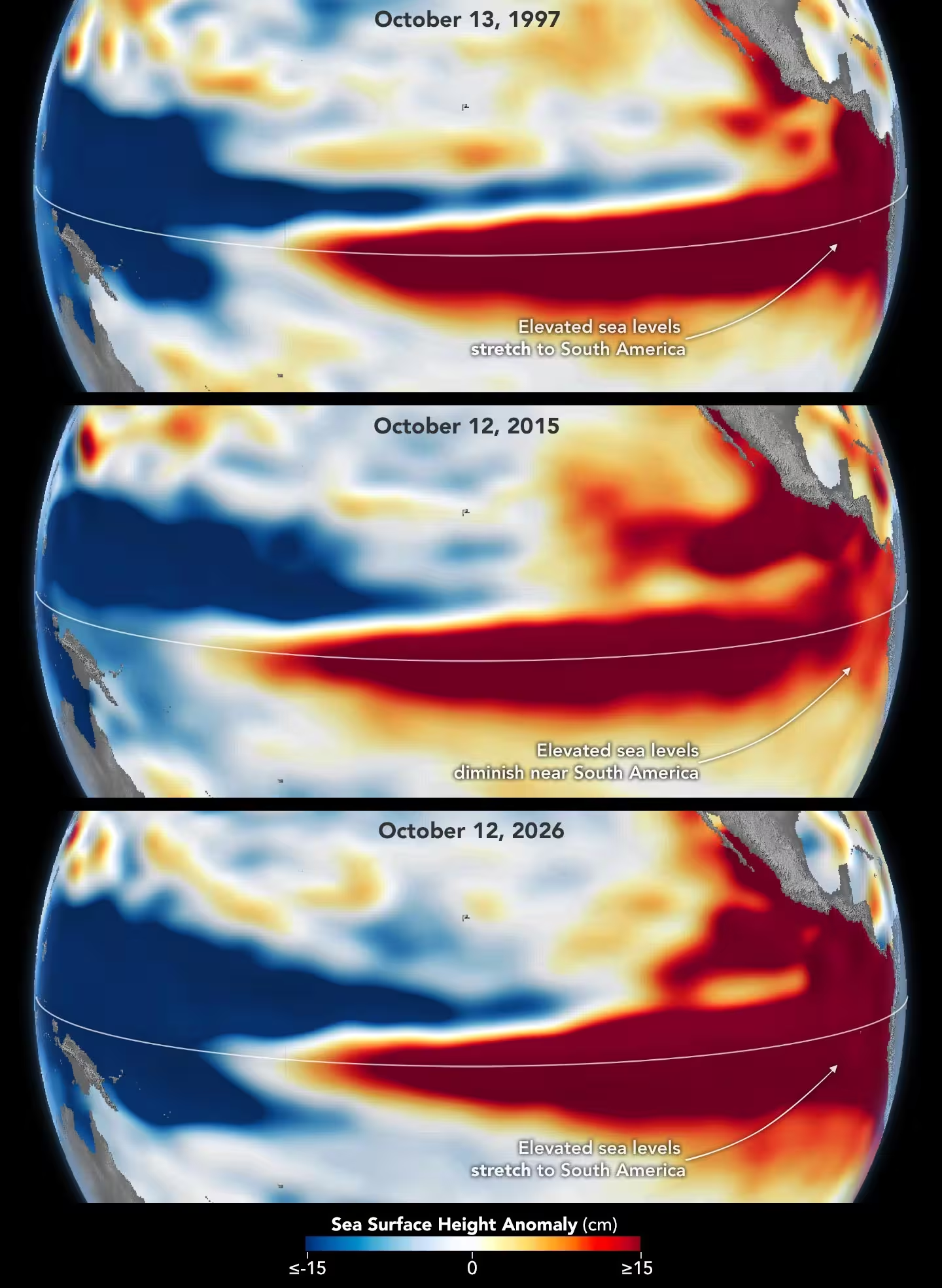
The 2015-16 El Niño was also very strong, as elevated sea levels in October 2015 (middle) show. But its pattern differed from those in October 1997 (top) and October 2026 (bottom): less of the elevated water reached the coast of South America, which contributed to different weather patterns that year.
Not all strong El Ninos behave the same way, though. Strength is only part of the story. Location matters. A pattern that stacks warm water squarely against South America tends to nudge storm tracks toward California and the southern United States. If the heat stays farther west, impacts shift—Central America, Mexico and the southeastern U.S. might feel the heaviest effects instead. The 2015–16 event, for example, packed intense equatorial warmth but less of it slammed into the South American coastline, and the resulting weather fingerprints were different.

So how does an El Nino grow? It often starts with the trade winds. Normally those winds shove warm surface water westward. When they slacken, warm water sloshes back east. That weakening nudges the winds to weaken further, sometimes even reverse, letting more warm water surge east in a feedback loop. Simple, in theory. Chaotic in practice.
Josh Willis, project scientist for sea level missions at NASA’s Jet Propulsion Laboratory, points out the challenge: 'The search for the "typical" El Nino is very elusive. They’re all different in terms of where they land and how their impacts play out.' He also notes that the continuity of altimetry records—satellites flying almost the same ground tracks for decades—allows a direct comparison between 1997 and now. And right now, this one is on track to be even bigger.
Forecasters are hedging but concerned. NOAA’s October outlook put the odds of a strong to very strong event through early 2027 at about 83 percent. Those odds capture the ocean’s state. They do not, however, guarantee identical weather outcomes. The atmosphere is a complicated partner. It can amplify ocean signals. Or it can scramble them.
Imagine rolling dice with the climate: the roll is weighted but not fixed. Even with 1997-like sea surface heights, winter weather will depend on how the atmosphere answers the ocean’s cue—where storms set up, how the jet stream bends, and which regions end up with rain or drought. Scientists can map the ocean’s heat with precision. Predicting the atmosphere’s choreography remains a finer art.
If this El Nino continues to unfold like the satellite data indicate, the coming winter could bring notable shifts in global weather patterns—though exactly where and how remains an open question.
Whatever unfolds, the message is clear: keep watching. New measurements will refine forecasts, and local preparedness will translate global signals into real resilience on the ground.


Leave a Comment
Comments (1)
wow, that 1997 comparison gave me chills. If this really rivals it, places will pay the price. Satellites are cool but still kinda scary... gotta stay alert