
3 Minutes
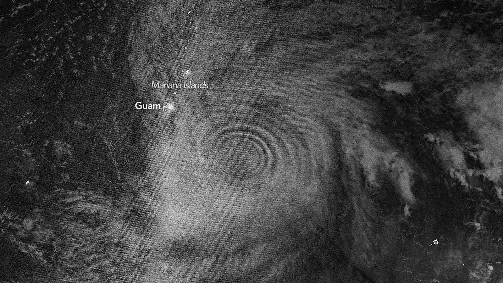
When Super Typhoon Sinlaku intensified over the North Pacific in April 2026, it didn’t stop at the ocean’s surface. The storm punched a visible wake into the upper atmosphere — concentric, rippling waves of light high above the clouds.
That spectacle was captured on April 12 by the VIIRS instrument aboard NOAA-20. In the sensor’s night-side view, faint mesospheric airglow traced out nearly complete rings expanding away from the storm, like a pebble’s splash frozen in the sky. Airglow is subtle: atoms and molecules that soaked up sunlight during the day release tiny amounts of light after dark, and under the right conditions it becomes a map of atmospheric motion.
Sinlaku was no ordinary cyclone. In a 24-hour span it erupted from a Category 2 equivalent into the violent, Category 5-class strength used by regional agencies — a remarkably early and rapid intensification for that part of the Pacific. That explosive upward heat and towering convection within the eyewall feed so-called "hot towers" that can send waves up through the troposphere into the stratosphere and mesosphere.

Those upward-propagating motions are gravity waves, not to be confused with gravitational waves from astrophysics. Here, gravity is the restoring force that produces oscillations in air parcels. Satellites saw their fingerprints at multiple altitudes: VIIRS revealed the luminous ripples in the mesosphere, while NASA’s Aqua satellite and its AIRS instrument picked up thermal signatures of the same waves in the stratosphere the following day. Follow-up imagery on April 14 showed the pattern persisting, evidence that Sinlaku’s influence lingered well beyond the storm’s fiercest hours.
Scientists working with the data were struck by how intact those rings remained. Upper-level winds often shear apart gravity waves before they can reach such heights. But in April’s atmospheric setup, stratospheric winds above the storm were unusually weak, allowing the waves to climb and spread with minimal disruption. The moon helped too: with only a quarter of the Moon illuminated, reflected light from clouds was low enough that the faint airglow signal could be detected by VIIRS’ day-night band.
Why should anyone care about ripples in a layer of faint light tens of kilometers up? Because they are information-packed. Gravity waves carry signatures of storm vigor and structure. Researchers argue that detecting these waves from space could become a remote diagnostic for intensification — especially valuable over vast ocean regions where direct observations are scarce. Continuous infrared monitoring from future geostationary platforms, for example, might let forecasters track wave patterns in near real time and get earlier clues that a cyclone is strengthening.
The story does not stop at weather forecasting. Gravity waves couple layers of the atmosphere. They alter momentum and wind patterns in the stratosphere, which in turn modulates longer-range climate and seasonal forecasts for the Northern Hemisphere. And they can even reach ionospheric heights, where they trigger traveling ionospheric disturbances and create plasma irregularities that disrupt GPS, radio communications and some satellite signals.
A single tropical cyclone can push effects from the sea surface all the way to the edge of space. That linkage — water to weather to near-space disturbance — is a reminder that Earth’s systems are profoundly interconnected. If storms can write ripples into the sky, watching those ripples may change not only how we forecast extreme weather but how we protect the technologies that rely on a quiet upper atmosphere.

Leave a Comment
Comments
No comments yet. Be the first.