
6 Minutes
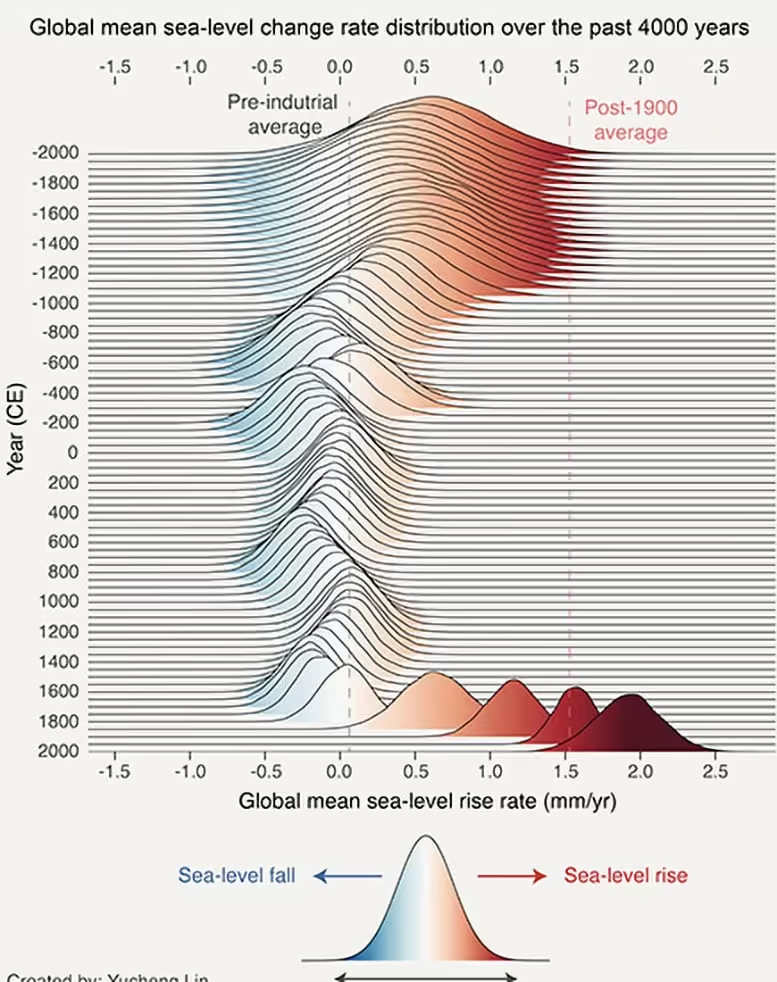
New research led by Rutgers University shows modern sea level rise is accelerating faster than at any time in the last four millennia. By reading natural archives—ancient corals, mangroves and other coastal sediments—scientists reconstructed sea level changes across the Holocene and found a marked modern spike tied to warming and human activity.
Reading the planet's memory: corals, mangroves and millennia of data
To understand how today's oceans compare with the deep past, researchers compiled thousands of geological records from sites around the world. Corals and mangrove deposits preserve clear markers of former sea levels; by dating those markers, the team traced coastal elevations through nearly 12,000 years of the Holocene epoch. The long view makes one fact stark: since 1900 global mean sea level has increased at about 1.5 millimeters per year—roughly one-sixteenth of an inch annually—which is the fastest century-scale rise observed in at least 4,000 years.
That acceleration matters because slow, steady changes allow societies to adapt; sudden or rapid shifts outpace planning. The paper, published in Nature, underscores how geological archives can be combined with modern measurements to set a baseline for current change and to highlight where risk is growing fastest.
Why sea level is speeding up: heat and melting ice
Two physical processes explain most of the modern acceleration: thermal expansion and mass added to the oceans from melting ice.
Thermal expansion
Oceans absorb more than 90% of the excess heat trapped by greenhouse gases. As water warms it expands—an effect called thermal expansion—that increases ocean volume even without adding water. This volumetric expansion is a steady contributor to rising seas.
Glaciers and ice sheets
Smaller glaciers and the edges of continental ice sheets are melting faster as temperatures climb. Greenland and parts of Antarctica are losing ice mass at accelerating rates, and that meltwater flows into the ocean, raising the global mean. The study highlights particularly rapid changes in Greenland—today’s glacier response is faster than seen in many centuries.
Delta cities face a double threat: sea level rise plus subsidence
Rising oceans are a global issue, but some regions face a compounded danger. Low-lying delta regions—places where rivers meet the sea—are natural magnets for agriculture, transport and urban development. That attraction is exactly why many of the world's economic powerhouses sit on deltas: they are flat, fertile, and accessible by water.
However, deltas are also prone to subsidence, the gradual sinking of land. Subsidence can be caused by natural compaction of soft sediments, but human activities—especially groundwater and hydrocarbon extraction—can accelerate it dramatically. The Rutgers-led team focused on China’s Yangtze and Pearl River deltas, home to megacities such as Shanghai, Shenzhen and Hong Kong, and found alarming interactions between global sea level rise and local subsidence.
In Shanghai, for example, excessive groundwater extraction during the 20th century caused parts of the city to sink more than one meter—orders of magnitude faster than the global mean sea level rise. When land sinks while the ocean rises, flood risk multiplies. Even centimeters of additional sea level can substantially increase the frequency and severity of coastal inundation in heavily populated deltas.
Mapping vulnerability and taking action
The study does more than document past and present trends: it produces vulnerability maps that help planners pinpoint subsidence hotspots and prioritize interventions. For delta regions, mitigation strategies include strict regulation of groundwater withdrawal, managed aquifer recharge (reinjecting freshwater into depleted underground layers), land-use planning that avoids high-risk zones, and engineered coastal defenses where appropriate.
There are already signs of adaptation. Shanghai, after recognizing the problem, tightened groundwater controls and implemented programs to slow subsidence. Such measures show that policy can change trajectories—but only with timely investment, enforcement and integrated planning that considers both global sea level projections and local ground-level dynamics.
Implications for global supply chains and infrastructure
Delta regions are not just locally important: they host global manufacturing hubs, ports and supply-chain chokepoints. Flooding or chronic inundation in these areas would ripple through world trade, affecting industries and consumers far from the shoreline. The combination of thermal expansion, accelerated glacier melt, and ongoing human-driven subsidence elevates the risk profile for many coastal megacities—from New York and Jakarta to Manila and beyond.
Effective response requires integrating geological insights with modern monitoring (satellite altimetry, GPS-based land motion measurements, tide gauges) and translating that information into zoning laws, infrastructure upgrades, and climate-resilient economic planning.
Expert Insight
"The geological record is indispensable for distinguishing long-term natural variability from the human-driven acceleration we're seeing now," says Dr. Mara Heller, a coastal geoscientist (fictional) with two decades of work on deltas. "Cities can adapt, but they must act on both fronts: reduce greenhouse gas emissions to slow global rise, and fix local practices—like unregulated groundwater pumping—that make the problem worse locally."
Her point underscores a central message: the drivers of sea level rise operate at planetary scales, but impacts and solutions often play out at the neighborhood level.
What to watch next
- Improved satellite and tide-gauge networks will refine short-term projections for regional seas.
- Monitoring subsidence with dense GPS networks can reveal fast-changing hotspots requiring urgent policy response.
- Engineering and nature-based solutions—wetland restoration, managed retreat, and resilient infrastructure—will be tested and scaled in the decade ahead.
Understanding the combined forces of thermal expansion, ice loss, and land subsidence is essential for realistic risk assessment. The Rutgers-led study amplifies a clear warning: current sea level trends are unprecedented in thousands of years, and coastal communities must prepare now to protect people, economies and critical infrastructure.
Source: scitechdaily
Comments
skyspin
Is this even true? corals and mangroves are neat proxies but local subsidence could skew the signal... curious to see more regional data
labcore
Whoa, 4,000 years? thats terrifying... If Shanghai sank meters from groundwater, imagine other deltas. We gotta act fast, but politics sucks, ugh
Leave a Comment